Three Ways to Measure a Yard
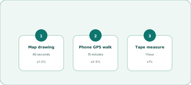
There are exactly three practical ways to measure outdoor area, and each has a job it wins. Knowing which is which saves both hours and money.
1. Drawing on a map — the 60-second default
Trace the boundary in the map tool and read area and perimeter in four units. Accuracy runs 1-2% against reality at property scale — better than almost any purchase decision requires. It wins whenever the boundary is visible in satellite imagery (lawns, roofs, fields, lots) and whenever you are planning rather than cutting. It loses where imagery is stale, blocked by canopy, or legally insufficient.
2. Walking with GPS — for the big and the invisible
Walk the boundary with a tracking app and read the recorded area. Drift is 2-5 meters per fix, which averages out over a 400 m perimeter (a 40-hectare field barely notices) but dominates a 20 m-wide town yard. GPS wins for large tracts, rough land where imagery shows nothing useful (brush, forest), and for verifying that the map matches the ground.
3. Tape and wheel — the ground truth
A 30 m tape (or a measuring wheel for longer runs) is tedious and unglamorous and exactly right for short, money-critical spans: the fence bay between two fixed corners, the countertop-width gate gap, the sod rows. Where the number turns directly into a cut dimension, the tape outranks everything.
Choosing in one table
| Job | Use | Why |
|---|---|---|
| Lawn products, roof quotes, land planning | Map drawing | 1-2% is finer than any purchase needs; done in a minute |
| Large tracts, overgrown land, no imagery | GPS walk | Errors dilute over distance; works where maps cannot see |
| Cut lists, bays between fixed points | Tape / wheel | Centimeters matter; nothing else is honest at that scale |
| Legal boundary, property sale | Survey | Only a surveyor's plat stands in a dispute |
The professional move: measure twice, differently
Before big orders, cross-check two methods: draw it on the map, then pace the two longest sides (your stride is roughly your height × 0.41). If the numbers agree within a few percent, order with confidence; if they disagree, one of your assumptions (an imagery offset, a fence line you misread) needs a second look — much cheaper to discover now. And for the record: pacing works for checking, not for ordering — a 5% pacing error on a 40-acre field is two acres of seed that never gets planted.
Frequently asked questions
How accurate is measuring on a map?
For property-scale shapes, 1-2% against the imagery's real-world scale — plenty for buying materials or planning. Imagery can be misaligned by a meter or two in some areas; for legal boundaries, a survey wins.
Is walking the boundary with GPS accurate?
Phone GPS drifts 2-5 meters per reading; the errors average out over a big perimeter, which is why GPS suits large tracts and disappoints on small yards where 3 m of drift is a real fraction of the width.
When do I actually need a tape measure?
Short, money-critical spans: fence bays between fixed posts, material cuts, anything under ~30 m where map resolution and GPS drift both matter more than a tape's tedium.